
Ohio Water
Protecting Ohio’s Waters…and You!
Here you will find a variety of information related to Ohio water resources. Find an area that you might be interested in learning more about by clicking on one of the five sections below.
Surface Water Quality
Ohio Ground Water Program and Ohio Observation Well Network
Public Drinking Water/Source Water Protection
Soil and Water Conservation
Ohio Geology, Map, Publications and Educational Resources
Surface Water Quality
Ohio Ground Water Program and Ohio Observation Well Network
Public Drinking Water/Source Water Protection
Soil and Water Conservation
Ohio Geology, Map, Publications and Educational Resources
Surface Water Quality

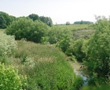
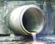
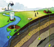
Ohio Nonpoint Source Pollution Control Program - Nonpoint source is pollution that is the result of land use activity or disturbance of the stream or aquifer system. Sources can be classified into two categories: polluted run-off and physical alterations. Polluted run-off is rain and snow melt flowing across the land surface or within ground water that picks up contaminants and carries them to the stream or into the aquifer. Physical alterations are changes made to a stream channel or stream banks and include activities such as the conversion of headwater streams into drainage ditches, constructing levees and dams, straightening a stream to encourage improved drainage. Other physical alterations include removing trees along a river bank or installing rock rip-rap on a river bank to prevent erosion.

Ohio Nonpoint Source Pollution Management Program 2005-2010 – The overall purpose of the plan is to present State of Ohio NPS partner strategies to restore and maintain the chemical, physical and biological integrity of water bodies within the state, an objective of the Clean Water Act. The short-term goal for Ohio is to have 80% of streams in attainment with aquatic life use standards by 2010.
Water Quality Management Plans – An encyclopedia of information used to plot and direct actions that abate pollution and preserve clean water. A wide variety of issues are addressed and are framed within the context of applicable law and regulations. For some issues and locales, information about local communities may be covered in the plan. Other issues are covered only at a statewide level.
Water Quality Trading Program – Water quality trading is an innovative approach to achieve water quality goals more efficiently. Under the right circumstances, trading has the potential to yield both environmental and economic benefits, while promoting increased interaction among watershed stakeholders.

401 Water Quality Certification and Isolated Wetland Permits - The 401 Water Quality Certification and Isolated Wetland Permit Section reviews applications regarding dredging or fill projects that would physically impact waters of the state, including streams, lakes and wetlands.
Individual Ohio NPDES Permits (Industrial and Municipal Discharges) – The Ohio EPA issues National Pollutant Discharge Elimination System permits in order to protect Ohio’s water resources. Authorized permits allow the discharge of substances at levels that meet water quality standards. Permits establish other conditions related to water issues such as combined sewer overflows, pretreatment and sludge disposal.
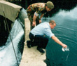
Statewide Biological and Water Quality Monitoring & Assessment – Ohio EPA routinely conducts biological and water quality surveys, or ‘biosurveys’, on a systematic basis statewide. A biosurvey is an interdisciplinary monitoring effort coordinated on a waterbody specific or watershed scale. The data gathered by a biosurvey is processed, and evaluated in a biological and water quality report. The findings and conclusions of each biological and water quality study may factor into regulatory actions taken by the Ohio EPA.

Storm Water Program – Storm water discharges are generated by runoff from land and impervious areas such as paved streets, parking lots, and building rooftops during rainfall and snow events that often contain pollutants in quantities that could adversely affect water quality.
Wastewater Permit-to-Install (PTI) Program – A PTI is needed when a person wishes to construct any wastewater collection, storage or treatment system or wishes to modify any existing wastewater collection, storage or treatment system.
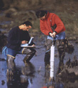
Volunteer Monitoring Program - There are many watershed groups, community associations, educators, local governmental organizations, and private sector businesses that collect water quality data in Ohio. The purposes of these sampling efforts vary, as do the methods, quality control and data reporting procedures used. Ohio EPA, has adopted rules for the surface water monitoring program designed to encourage and oversee the collection, analysis and use of data collected by volunteer individuals and organizations. We hope that more water quality monitoring will be done by volunteers, both professionals and non-professionals, now that a formal program exists and that sharing water quality data will benefit volunteers, state agencies and others in Ohio.
Ohio Ground Water Program and Ohio Observation Well Network
Ground Water Program – The Ohio Environmental Protection Agency (Ohio EPA) is the designated state ground water quality management agency for preventing and addressing ground water quality problems. The Ground Water Quality Characterization Program meets this responsibility by: Coordinating state-wide ground water monitoring; Characterizing ground water quality conditions in Ohio’s major aquifers; Identifying ground water contamination; Determining cause and effect relationships; and Recommending strategies for preventing contamination. To learn more about Ground Water Level Monitoring in Ohio clickhere.
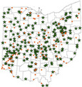
Ground Water Monitioring Locations in Ohio – Ohio EPA Division of Drinking and Ground Waters (DDAGW) maintains the Ambient Ground Water Monitoring Network as part of an effort to characterize general water quality conditions in Ohio. This program to sample raw (untreated) water was originally established in 1967 to measure seasonal and annual water quality changes in the State’s major aquifers. A central goal of the Ambient Ground Water Monitoring Program is to provide reliable ground water quality data to enhance water resource planning and protection on a state-wide basis.
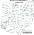
Ohio Observation Well Network – This site provides access to all active wells participating in the Ohio Observation Well Network. The data collected from observation wells since 1938 has proven to be a valuable tool in the Water Resources Section’s effort to promote the wise and efficient use of Ohio’s rich ground water resources. This on-going scientific program sheds new light on Ohio’s aquifer characteristics, provides documentation in user conflicts and records a historical account of how variable climatic conditions effect Ohio’s ground water resources.
Ground Water "Buried Treasure" – This site was developed by the Ground Water Protection Council in helping to promote the protection and conservation of ground water resources for all beneficial users, recognizing ground water as a critical component of the ecosystem.
Public Drinking Water/Source Water Protection
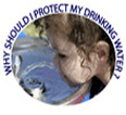
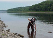
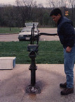
Ohio Drinking Water – Drinking water, which may be from ground water, surface water, or both, is vulnerable to being contaminated. If the drinking water source is not protected, contamination can cause a community significant expense as well as endanger people’s health. Many public water systems in Ohio have taken measures to ensure that the water they serve to the public is clean and safe.

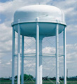
Drinking Water Basics- Public water systems (PWS) are regulated by the Ohio Environmental Protection Agency, Division of Drinking and Ground Waters. A public water system is defined as a system that provides water for human consumption to at least 15 service connections or serves an average of at least 25 people for at least 60 days each year. This includes water used for drinking, food preparation, bathing, showering, tooth brushing and dishwashing. Public water systems range in size from large municipalities to small churches and restaurants that rely on a single well. Follow the link to learn more about three types of public water systems: Community water systems, nontransient noncommunity systems, and Transient noncommunity systems.

Ohio EPA’s Source Water Protection Program – Ohio’s Source Water Protection Program helps public water suppliers protect drinking water sources, such as streams and aquifers, from contamination. It addresses the more than 5,000 public water systems in Ohio. The source water protection program has two phases: collecting information about the source water – the assessment phase and developing and implementing a local drinking water source protection plan.
Annual Public Water System Compliance Reports – Ohio’s Annual Compliance Report contains an overview of the Public Water System Supervision Program in Ohio; provides summary information on the number, types and population served for public water systems; explains the requirements of the Annual Compliance Report; defines the primary categories for which violation information is summarized; a summary table of the number and types of violations; an analysis of public water system compliance with the regulations; and a list of public water system violations for the maximum contaminant level and treatment technique categories.
Soil and Water Conservation
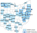
Source Water Environmental Education Teams (SWEET Program) – Providing Ohioans a local resource for source water environmental education and guidance for protecting their community’s water resources. Each team, mostly organized by county soil and water conservation district staff, consists of three to five local water resource partners such as local health departments, watershed coordinators, and public water system operators. The teams are quickly becoming an important component of source water protection education efforts across the state.

The Ohio Federation of Soil and Water Conservation Districts (SWCD’s) – The Ohio Federation of Soil and Water Conservation Districts has a rich and diverse history of conservation efforts in Ohio. For over 68 years, they have been the leader in conservation stewardship.
Ohio Geology, Map, Publications and Education

Ohio Geological Survey - The Division of Geological Survey is the state’s oldest natural resources agency, established by the Ohio legislature in 1837. The Division, known informally as the Ohio Geological Survey, has been in continuous operation since 1900 and is one of the seven originally chartered divisions of the Ohio Department of Natural Resources, which was created by the legislature in 1949. At this site you will be able to access geologic maps, reports, and data files developed by the Division.

Geologic Maps of Ohio – Access a variety of page-size geology map PDF’s that you can print out for your use.
Interactive Maps – Since 2004, the Division of Geological Survey has developed and maintained several Web-based mapping systems that provide important information about how geologic and human activities shape Ohio and impact its cultural and economic development. These mapping applications utilize the division’s numerous data sets on oil and gas wells, abandoned underground mines, mineral industries and more.

Educational Resources – Access a variety of interesting educational resources from GeoFacts (2 or 3 page fact sheets) on a variety of topics to "Hands on Earth Science" and much more.

Publications – Access a variety of interesting educational resources from GeoFacts (2 or 3 page fact sheets) on a variety of topics to “Hands on Earth Science,” Guidebooks, Multimedia Library and much more.


